-

If you’ve ever wondered how the global average temperature is calculated, especially considering that we don’t have surface temperature observations at many point on the globe (especially the poles), then this article is for you. The Climate Lab Book blog from the U. K., provides an excellent scientific overview of how a global mean temperature…
-

After a very quiet couple of months, the Atlantic tropics are beginning to heat up, just as the most active period of hurricane development begins. The sea surface temperatures, which were near record-setting cold earlier in the year, are now close to normal, and the plumes of Saharan dust which were also inhibiting storm formation…
-
If you have ever been asked to provide a summary of your state’s climate, here is a good resource for you. The National Centers for Environmental Information have a set of state climate summaries available at https://statesummaries.ncics.org/. These summaries look at past climate state by state and also look at future climate scenarios that help you…
Posted in: Sources of weather and climate data -

As we approach the peak of the Atlantic hurricane season, I am seeing many stories in my social media feeds about the anniversaries of past tropical systems that have affected the Southeast. Here is one remembrance of TS Bonnie from the State Climate Office of North Carolina discussing why Bonnie has been overlooked in the…
-

If you think you might need climate data but are not sure what you need or where to get it, NOAA has produced a simple primer that provides answers to some of your basic questions about weather and climate data. Check it out at Climate.gov at https://www.climate.gov/maps-data/primer/climate-data-primer. If you are still stuck after that, let me…
-
Scientists for the past 100 or more years have known that the climate is changing due to the addition of carbon dioxide into the atmosphere. Basic physics tells us that if you add more greenhouse gases to the atmosphere, things are going to warm up. And we know that most (but not all) of the…
-
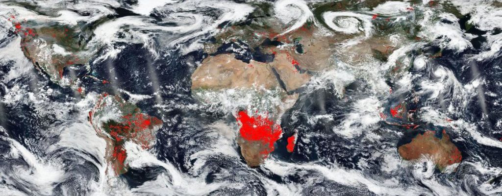
Did you know that NASA’s satellites can identify surface fires from space? They use the thermal imaging wavelength band to find hotspots that correspond with fires that are either wildfires or are human-set burns in agricultural areas. NASA produces a map which shows these fires across the globe. You can read more about the map…
Posted in: Interesting weather images