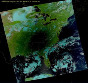
Lots of great images today from the eclipse! I was at 99.1% totality at Sanford Stadium in Athens GA with about 30,000 other people watching the darkness descend. Here’s a great shot from the VIIRS satellite radiometer showing the shadow over the Southeast. The text explanation is below. You can also watch video of the shadow moving across the US at https://www.nesdis.noaa.gov/content/multimedia.
The Visible Infrared Imaging Radiometer Suite (VIIRS) aboard the NOAA/NASA Suomi NPP satellite captured this color-enhanced infrared image of the moon’s shadow over the Midwest/Southeast during today’s solar eclipse.
This so-called “natural color” RGB composite image was made by combining data from VIIRS channels I-01, I-02 and I-03. In the resulting image, vegetation appears green, liquid clouds appear white, and ice clouds appear cyan.
VIIRS provides coverage of the entire globe twice a day with 750 meter resolution across its entire scan. In doing so, it offers better coverage than its instrument predecessors, and provides more detailed images of meteorological and environmental phenomena, including vegetation health, phytoplankton abundance, smoke plumes, aerosols and dust.
