What can we expect for this year’s growing season based on past conditions and current climate predictions? Here is a quick look back and then a discussion of what we think is most likely to occur.
In spite of the cold outbreak in mid-March across the Southeast, year-to-date temperatures are in the top five warmest on record for most parts of the region. The average temperatures from January 1st on have been an average of five degrees above normal. The result of that early warming in spring was that many plants came out of winter dormancy almost three weeks earlier than usual, leaving many farmer eager to get out and start planting. Rainfall across the area has been somewhat variable, with the year-to-date totals showing below average precipitation, although the first week of April brought flooding rain to many places in the Southeast. The early dryness has caused deficiencies in soil moisture which have led to the development of “abnormally dry” conditions across the region according to the Drought Monitor, although those have been somewhat reduced by the rain last week. Streamflow in many rivers has also been below normal because the early-growing plants sucked up any available moisture that fell, leaving less to move into the ground or run off.
The short-term and long-term outlooks show that temperatures are likely to continue to be above normal. In the near term, our weather is likely to be dominated by high pressure, which will keep skies sunny and temperatures on the warm side. A few passing fronts may drop some showers but no big rain events are currently expected, which may bring abnormally dry soil conditions back to the area, especially as the warmer than normal temperatures lead to higher evaporation rates.
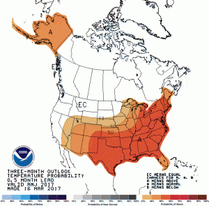
Over the rest of the growing season, the likelihood of above-normal temperatures continues all the way into next winter. This is based on trends towards warmer temperatures that have occurred across the region from the 1970’s on as well as the absence of a strong El Nino or La Nina. Prediction of precipitation is difficult in neutral conditions, and NOAA’s Climate Prediction Center shows equal chances for below, near and above normal precipitation in the next year, indicating their lack of skill. However, they do provide a hint of above normal rainfall in the western Gulf of Mexico region which may be tied to unusually warm waters which are present now in the western Gulf.
ENSO conditions are currently in the neutral phase, which means that no La Nina or El Nino is present. While spring is a tough time to predict the phase of El Nino in the coming fall and winter, climate forecasters currently believe that an El Nino is likely by mid- to late summer. With this in mind, the forecasts for the Atlantic tropical season predicted that there will be fewer than usual storms, because the developing El Nino’s strong subtropical jet stream will “blow the top off” of any developing storms, keeping them from getting strong enough to become full-fledged storms. I think that with the Gulf of Mexico having such warm water temperatures now, we may see some early storms develop in that region, potentially bringing rain to the Southeast as the storms move out of the Gulf. Later in the season, if the El Nino develops as expected, less tropical storm activity is likely, leading to a potential for another dry fall. Of course, as we saw last year with Hurricane Matthew, a single storm can cause all kinds of havoc with winds and flooding rain, so even in a season that is not very active, you can still get tropical impacts.
The bottom line: expect warmer than normal temperatures to continue through most of the growing season (with some breaks for cool incursions from time to time), more rain early in the growing season, and a potential increase in dry conditions later in the year in areas that are not directly affected by any passing tropical storms.
