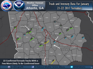
I want to give a shout-out to the National Weather Service employees in the Southeast this week who have been out surveying tornado damage this week following the severe storms we had in several states. The map below shows the tornado tracks that have been identified by NWS employees from just the Peachtree City office so far, with a few sites left to survey. (Other parts of the state will be surveyed by crews from their corresponding NWS office). Each one of these tracks was identified by a crew on the ground looking at damage levels to buildings and patterns of tree fall to assess where the tornado track started and stopped and what the Enhanced Fujita scale was for each storm. This takes a tremendous effort to do accurately, and I think they should be applauded for doing this important work on top of all of their regular activities! The information is used by insurance companies, city and county planners, emergency managers and many others who need to know about severe weather in their area.
