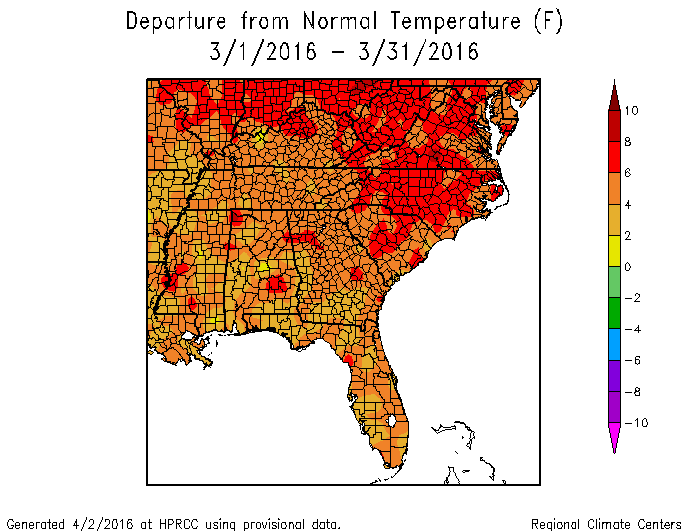
Georgia was well above normal in temperature in March, ranging from three to over six degrees above the 1981-2010 average. Rainfall was generally less than normal across the state with the exception of the southwest corner and near Savannah.
In Atlanta, the monthly average temperature was 60.5 degrees F (6.2 degrees above normal), in Athens 59.9 degrees (5.6 degrees above normal), Columbus 61.9 (4.1 degrees above normal), Macon 61.1 (4.3 above normal), Savannah 65.0 (5.8 above normal), Brunswick 64.9 (4.6 above normal), Alma 63.6 (3.4 above normal), Augusta 60.8 (4.9 above normal), Albany 63.7 (4.5 above normal), Rome 56.8 (4.7 above above normal), and Valdosta 64.7 (4.6 degrees above normal).
Multiple high temperature records were set on March 15 across the state. Atlanta reported 85 F, Athens 86 F, Alma 87 F, and Columbus 87 F, breaking the old records of 82 F, 85 F, 86 F and 86 F, respectively, all set in 2012. Macon also tied their record of 87 F on the same day. Augusta, Savannah, and Brunswick also tied records on or near that date. Brunswick also broke a record high on March 14, recording 84 F, which surpassed the old record of 83 F set in 1975. Two record high minimum temperatures were also tied at Alma and Brunswick in that time period.
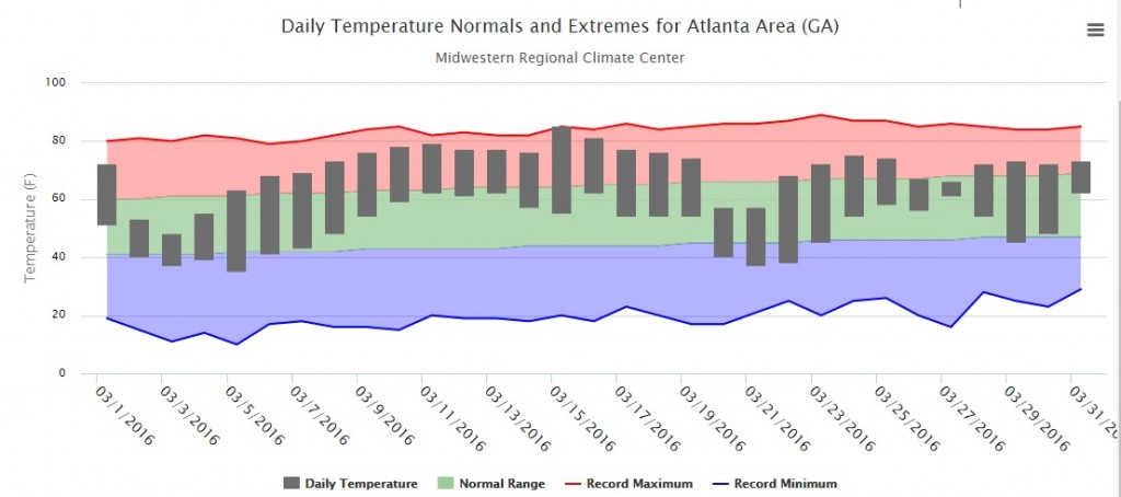
The thermograph for Atlanta above shows that most of the month was above normal in temperature, with only two short time intervals of below normal temperatures.

The highest monthly total precipitation from National Weather Service reporting stations was 6.17 inches in Valdosta (1.30 inches above normal) and the lowest was in Brunswick at 1.56 inches (2.32 inches below normal). Atlanta received 2.21 inches (2.60 below normal), Athens received 1.95 inches (2.48 inches below normal), Columbus 2.56 inches (2.90 below normal), Macon 2.64 inches (1.91 below normal), Savannah 5.01 inches (1.28 above normal), Augusta 3.18 inches (1.00 below normal), Alma 2.87 inches (1.88 below normal), Albany 4.77 inches (0.28 below normal), and Rome 4.86 inches (0.09 below normal).

Savannah set a daily precipitation record on March 27 when 3.98 inches fell at the airport, far surpassing the old record of 2.57 inches for that date set in 2005.
The highest single-day rainfall from CoCoRaHS stations was 4.57 inches measured one mile north of Pooler in Chatham County on March 28, followed by two other Pooler observers who measured 4.25 and 3.98 inches on the same date. That was part of the same storm that brought the daily record rainfall to Savannah, but since CoCoRaHS observers report in the morning, their observations were reported on March 28 instead of on March 27 as the National Weather Service observer did, reporting midnight to midnight amounts. The highest monthly rainfall of 7.89 inches was measured south of Donalsonville in Seminole County, followed by 7.25 inches in Thomasville in Thomas County and 7.09 inches measured in Bainbridge in Grady County, all in the southwest part of the state.
Snow was measured by several observers in the northern part of the state on March 4. The highest amounts were 2.0 inches measured near Dillard in Rabun County and Nelson in Pickens County. This was the only day of the month with snow, so these are also the monthly totals.
Severe weather was observed on five days during the month. The most notable was a brief tornado touchdown eight miles west of Pelham in Grady County on March 31 which caused some damage to trees and powerlines.
Because of the lack of rainfall, abnormally dry conditions expanded over the state during the month. This allowed farmers to get into the fields to do planting and chemical applications, but dry conditions caused some concerns for germinating crops. Wet conditions in the southwest corner hampered farmers’ ability to work in the fields and led to the development of some fungal diseases by the end of the month.
The warm conditions across the state caused early blooming of many trees and flowers, leading to very high pollen counts which were not helped by the lack of rain to wash the pollen out of the air. The early blooming in the northeast part of the state led the National Weather Service to start issuing frost warnings there earlier than usual because of farmers’ concerns about the fruit trees. In spite of the cold weather in late March, most fruit trees across Georgia were not affected by frost, and a good and flavorful peach crop is expected this year unless a very late frost occurs in April.
The outlook for April shows colder than normal temperatures in the beginning of the month but a return to warmer than normal conditions later. Precipitation is expected to be above normal in the first half of the month but drier conditions may return in the last two weeks. The April through June outlook shows that warmer and wetter than normal conditions have the highest probability of occurrence.
For more information please see the “Climate and Agriculture” blog at https://site.extension.uga.edu/climate/ or visit our new web page at https://www.gaclimate.org. Please feel free to email your weather and climate impacts on agriculture to share on the blog to pknox@uga.edu.