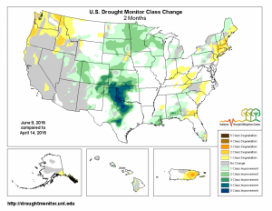
The National Drought Monitor collects and disseminates drought information for the United States each Thursday morning after seeking input from climatologists and other stakeholders around the country. One of the products they provide is a map of changes in drought status for the US. The map below shows the change in drought status for the past two months. You can get other time periods at https://droughtmonitor.unl.edu/MapsAndData/ChangeMaps.aspx.
The map highlights the shift in rainfall that we have seen in the Southeast in the past two months. At the beginning of the time period (April 14, 2015) conditions in the Southeast were normal to dry, particularly in southeast Alabama. Since then, heavy rains in the western part of the Southeast linked to the tremendous rains in the south-central Plains have wiped out that drought. However, the lack of progression of the rainy area has left southeast Georgia and south into Florida drier than normal, leading to the development of drought there. The next week of hot and dry weather will likely increase the area and intensity of the drought there by next week’s Drought Monitor.
