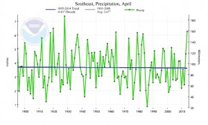
Since we’re in a new month, I thought I would show you the long-term trends in temperature and precipitation for the Southeast.
Many of you remember how wet last April was and how difficult it made field work. It was one of the top five wettest on record for the Southeast. However, the trend line for precipitation is almost flat, indicating no long-term trend in April. This gives us some hope that this coming April will be closer to normal. Since March was dry across the region, however, we do need timely rains to continue across the area to hydrate crops that are already growing.
Temperatures, on the other hand, show a long-term warming trend. A lot of this warming has come since the 1970s, although cold years early in the record (which starts in 1895) also contribute to that trend. The last few years have all been above the long-term average.
If you want to see trends lines for your own state or climate division within a state, you can generate these at https://www.ncdc.noaa.gov/cag.

