The latest Drought Monitor has brought abnormally dry (D0) conditions back to Georgia for the first time since last December (https://droughtmonitor.unl.edu/). According to the discussion for the Southeast, 30-day moisture deficits and declining soil moisture and pasture conditions have led the authors to conclude that we may be in the early stages of a “flash” drought across a broad band of the Southeast. John Christy, the Alabama State Climatologist, was interviewed for AL.com in an article posted here. In it he said that flash droughts are rapidly occurring and are caused by a combination of high temperatures and stoppage of rainfall. They occur most frequently in areas where the soils have poor moisture-holding capacity, like most of the Southeast, and are especially damaging for agriculture because they tend to happen during the peak growing season.
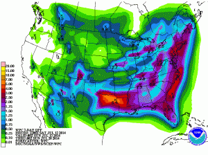
Rainfall predictions for the next two weeks (see recent blog entry) show that we are expected to be cooler and wetter than normal for the next two weeks as a whole; if those forecasts hold true that could alleviate some of the dry soil conditions we are currently seeing. For the next few days, we can expect to see continued daily thunderstorm activity and the chance for some severe weather as a cold front approaches from the west on Tuesday, then sharply cooler and drier conditions after that for the next few days. The seven-day rainfall forecast shows that the areas in D0 conditions are expected to receive at least an inch, close to the the normal one inch per week we expect in the Southeast. This should mean that drought conditions should not deteriorate for the next two weeks, particularly with less evaporation in the cooler air.

