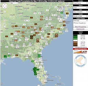
So far May has been feast or famine for rainfall in the Southeast. I saw standing water on the fields in northern Florida into southern Georgia as I drove back from Tallahassee to Athens last week, but dust clouds as I got close to home. This map shows the rankings of the month-to-date rainfall for National Weather Service coop stations across the region. Northern areas have seen rainfall totals that rank in the top ten driest, including Athens, GA, which has only reported a trace of rain so far this month. By contrast, areas in Florida, particularly around the Tampa area, have seen their top ten wettest May month-to-date rainfalls. This should change starting on Wednesday as a slow-moving cold front moves into the area from west to east, triggering thunderstorms across the region. Areas that are currently dry are expected to get 1-2 inches of rain starting on Wednesday. The highest amounts are likely to be in the northeast Georgia mountains, with up to 3 inches expected. The rain should end on Thursday afternoon for most areas, and cooler weather should reign for Friday through Sunday. A return to summer-like temperatures is likely by Monday.
If you are interested in creating your own ranking maps, you can go to the Southeast Regional Climate Center’s Perspectives page, www.sercc.com/perspectives, which allows you to list rankings of temperature and precipitation for individual stations or regional maps like the one above.
